 Thee National Association of Wetland Managers (formerly the Association of State Wetland Managers) developed this online training series focusing on hydric soils for wetland professionals. This training series has returned to its original format as a four module training series. It was designed for wetland field practitioners who need expertise in hydric soils and seek to understand how hydric soils are formed and how to recognize and interpret the information they provide when observed in the field. These can also be used as refresher courses for those practitioners who have not had soils training in recent years.
Target Audience
Wetland professionals, specifically state and tribal wetland field staff (plus state/tribal wetland managers, local municipal officials, conservation commissions, boards of health and others).
Information about the Hydric Soils Training Modules (4 modules)
The training series spans four module topics - Basics of Hydric Soils, Hydric Soil Processes, Landforms and Landscapes, and Using Field Observations of Soils Onsite in Decision Making. Each module contains three training presentations.
Optional Module Quiz and Certificate of Completion for Use in Applying for Continuing Education Credits (CEUs)
Each online module in the Hydric Soils Training Series is accompanied by an optional knowledge assessment quiz available through ClassMarker. The quiz assesses understanding of the key take-away points of the training. See the ClassMarker tabs below for more information.
NAWM Members - as a benefit of membership, you may view the learning modules on your NAWM Member Portal and download a free Certificate of Completion for each module quiz that you pass. Log In to the membership portal to access the learning modules and quizzes.
 Non-Members - each module is available to purchase for $50.00 USD. Your module purchase provides access to view the learning module in Member365 and access the knowledge assessment quiz on ClassMarker. Secure payment is made through BAMBORA.
Registration for Module 1 is now open. Modules 2, 3, and 4 will be available soon.
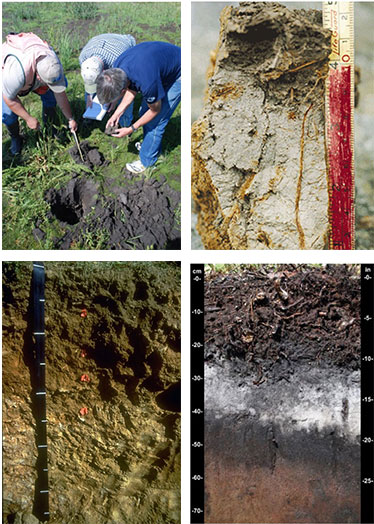
Module 01: Basics of Hydric Soils Trainer: Dr. W. Lee Daniels, Virginia Tech1 This training covers both the five factors of formation and horizonation vs. simple processes. The training begins with a review of redox reactions and redoximorphic features. Reduction and concurrent oxidation (redox) are the dominant chemical processes taking place in wetland soils. There are abiological and biological driven redox reactions in wetland soils. The session focuses on reactions driven by microbial breakdown of organic matter in soils under saturated conditions that lead to unique anaerobic conditions that meet the hydric soil definition of USDA. These redox reactions lead to mobilization of soluble Fe and Mn (depletion zones and surfaces) and subsequent reoxidation (concentration zones and surfaces), collectively called redoximorphic features. Redox feature types are identified through images. Description of the features is briefly reviewed, in preparation for use as components of field indicators of hydric soils 1B. Soil Texture and Structure Trainer: Dr. Ann Rossi, U.S. Environmental Protection Agency 1C. Describing Soil Color for Hydric Soils Determination Trainer: Lenore Vasilas, USDA Natural Resources Conservation Service This training focuses on describing soil color. Soil color and the color patterns in soil can tell you a lot about the soil. It is an especially good indicator of soil wetness and hydric soils. The primary components that give a soil its color are soil organic matter, iron, and the color of soil particles. The Munsell Soil Color System is the standard we use to document soil color. When documenting soil color, it is important to note matrix color, mottle colors, and type, location, and abundance of mottles. Module 02: Hydric Soil Processes 2A. Redox Reactions and Redoximorphic Features Trainer: Dr. John Galbraith, Viginia Tech This training begins with a review of redox reactions and redoximorphic features. Reduction and concurrent oxidation (redox) are the dominant chemical processes taking place in wetland soils. There are abiological and biological driven redox reactions in wetland soils. The training will focus on the reactions driven by microbial breakdown of organic matter in soils under saturated conditions that lead to unique anaerobic conditions that meet the hydric soil definition of USDA. The redox reactions lead to mobilization of soluble Fe and Mn (depletion zones and surfaces) and subsequent reoxidation (concentration zones and surfaces), collectively called redoximorphic features. Redox feature types are identified through images. Description of the features will be briefly reviewed, in preparation for use as components of field indicators of hydric soils. 2B. Hydric Soils Functions Trainer: Bruce Vasilas, University of Delaware This training focuses on wetland functions attributed directly to hydric soils. Functions are the biological, chemical, and physical processes that occur in wetlands. Hydric soils play a direct role in the wetland functions of water retention (short term and long term), sedimentation, carbon sequestration and biogeochemical cycling of nutrients. Due to their capacity to become anaerobic close to the surface, hydric soils support unique plant communities and wildlife habitat unlikely to be found in uplands. Functional capacity is influenced by landscape position, hydrologic characteristics, and soil characteristics. Soil characteristics that affect wetland functions include porosity, permeability, drainage class/hydroperiod, organic matter content, slope, micro-topography, and chemical properties. 2C. The Hydric Soil Technical Standard Trainer: Lenore Vasilas, USDA Natural Resources Conservation Service This training focuses on the Hydric Soil Technical Standard. The Hydric Soil Technical Standard (HSTS) provides a quantitative method of determining if a soil meets the definition of a hydric soil. The HSTS can be used to: 1) Identify a soils forming as hydric soils when a field indicator may not be present (e.g. wetland creation sites, problematic hydric soils); 2) Evaluate the current functional status of a hydric soil (e.g. change to hydrology); and 3) Propose changes to hydric soil indicators (e.g. expanding jurisdictional extent of an indicator, revising an existing indicator, adding a newly developed indicator). The HSTS requires quantitative measurements showing the soil becomes saturated and anaerobic in the upper part during normal precipitation years. Module 03: Landforms and Landscapes (Registration will open soon.) 3A. Landscapes and Hydric Soils Trainer: Dr. Bruce Vasilas, University of Delaware The training focuses on typical hydric soil morphologies associated with major wetland types-tidal marshes, peat bogs, perennially-inundated swamps, mineral soil flats, floodplains, depressions, and slope wetlands. The roles of landscape position, hydroperiod, and hydrodynamics on soil morphology will be emphasized. Soil morphology is impacted by the duration of inundation, and the seasonal vertical fluctuations in water tables. Water collecting surfaces such as closed depressions facilitate ponding; water shedding surfaces on slopes promote rapid movement of surface water through the wetland. Peat bogs are hydrologically isolated and permanently saturated; floodplains receive hydrologic inputs from overbank flow and groundwater discharge and exhibit short-term inundation. Therefore, because of differences in landscape position and associated hydrologic characteristics different types of wetlands produce distinctive hydric soils. 3B. Problematic Landscapes and Parent Materials (former mod 8) Trainer: Lenore Vasilas, USDA Natural Resources Conservation Service The training focuses on problematic landscapes and parent materials. Most hydric soils exhibit certain common morphological characteristics that allow you to identify them as a soil that meets the hydric soil definition. Problem soils are hydric soils that do not exhibit these common hydric soil morphologies. The lack of a morphological indicator despite the soil developing anaerobic conditions in the upper part can be caused by many things including problematic parent material, certain environmental conditions, and the replenishment of iron oxides or new sediments in the upper part of the soil. For some problem soils, alternate morphologies that can only be used in specific problematic situations have been developed. For those problematic situations where an indicator has not been identified, alternative methods of identifying the soil as hydric must be employed. These techniques are outlined in chapter 5 of the Corps of Engineers Regional Supplements. 3C. HGM and Hydric Soils (former mod 9) Trainer: Richard Weber, USDA Natural Resources Conservation Service The module focuses on the Hydrogeomorphic (HGM) system and hydric soils. The classification of wetlands in the HGM system is based on landscape position, dominant water source, and hydrodynamics – the magnitude and direction of water inflow and outflow. Information on these parameters is contained in soils information, which is housed in the Web Soil Survey and the soils database. While HGM interpretations are not provided directly, knowledge of soils attributes can be readily applied to make HGM class and sub-class designations. These attributes can be used to aggregate soil map units into HGM site concepts. A site concept is valid when all map units have similar water budgets, are in the same watershed position, and have the same water movement vectors. The HGM system also requires the definition of a Reference Domain, within which HGM classifications are valid. Since soil map unit concepts are generally consistent within a Major Land Resource Area, this boundary is the first selection for the Reference Domain. Since landscape position is more meaningfully defined as watershed position, the HUC-12 watershed scale is useful for heads-up testing of map unit aggregations. Since map units often need to be either aggregated, or disaggregated into components, the use of Digital Elevation Data is useful for performing these “lumping” or “splitting” operations. The final result should be a HGM sub-class with associated map units, or components, which can be mapped across the MLRA extent, and which is useful for land managers and conservation planners. Module 04: Using Field Observations of Soils Onsite in Decision Making (Registration will open soon.) Note: If you are not familiar with the basics of hydric soils, we recommend that you complete the earlier modules in the series prior to participating in Module 4 to optimize your learning experience. 4A. Using the NTCHS Indicators of Hydric Soils (Version 7.0) aka Field Indicators of Hydric Soils in the United States Trainer: John Galbraith, Virginia Tech This training focuses on using the NTCHS Indicators of Hydric Soils (Version 7.0) for onsite decision making about soils in the field. This module shares what resources you will need to use the indicators, how to access the electronic resources (including guides, errata sheets and more). The module will help participants understand the definitions of key terms for this work, as well as show how to combine the use of these resources effectively to aid decision making in the field. This module brings together many of the main concepts from earlier modules (e.g. soil textures, colors, landforms) and helps the participant understand their application in an applied setting. The module will cover important indicator caveats and provide other useful guidance for working with NTCHS Indicators of Hydric Soils in the field. 4B. Using Soil Science Principles for Wetland Mitigation, Voluntary Restoration and Creation Trainer: W. Lee Daniels, Virginia Tech The training focuses on how wetland professionals can use soil science principles in onsite decision making for work in the areas of wetland mitigation, voluntary wetland restoration and wetland creation. The training identifies common fallacies about wetland creation and reviews wetland soil reconstruction guidance protocols. The training includes a review of learning from 20 years of collaborative research on the limitations of created wetland soils. 4C. Using Field Indicators to Assess Long-term Hydrology Trainer: Dr. Bruce Vasilas, University of Delaware The training focuses on potential uses of Field Indicators of Hydric Soils to assess hydrologic characteristics of individual wetlands. This training does not teach about the Field Indicators themselves, but rather the benefits of hydrologic characterization and considerations for the use of the Field Indicators in onsite decision making. Notes: It is not the objective of this training presentation to provide training on the field Indicators themselves. Training on field indicators is available in Dr. Galbraith’s presentation earlier in this training. If you are not familiar with the basics of hydric soils, we recommend that you complete the earlier trainings in the series prior to participating in Training 4 to optimize your learning experience.
Module 01

Module 02
Module 03
Module 04
ClassMarker


