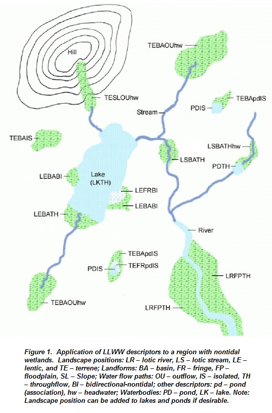
The LLWW Classification allows for enhanced classification of wetlands based on Landscape Position, Landform, Water Flow Path, and Waterbody Type (LLWW). To enhance the utility of NWI data for better characterizing wetlands and for preparing preliminary assessments of wetland functions from the NWI database, additional features had to be added to the NWI data. Key features included hydrogeomorphic features, specifically landscape position, landform, and water flow path. In addition, it was deemed important to better characterize waterbodies to identify a wide variety of pond types, and to separate natural lakes from created lakes, among other things, so waterbody type was also added to the NWI classification. Collectively, these descriptors have been referred to as "LLWW descriptors" with the letters representing the first letter of each additional descriptor (landscape position, landform, water flow path, and waterbody type). A set of dichotomous keys have been developed to define and classify these features. Figure 1 illustrates how these descriptors are applied to a nontidal region.
Five landscape positions for wetlands are recognized: marine (ocean intertidal shores), estuarine (estuarine intertidal shores), lentic (lake or reservoir shores), lotic (river and stream shores and floodplains), and terrene (isolated or not subject to overflow from rivers, streams, or lakes). Landforms include basin (depression), flat (broad nearly level landform), floodplain (subject to river overflow), fringe (shallow-water wetland, bank, or tidal wetland with unrestricted flow), and slope (>2% slope). Several water flow paths are defined: inflow, outflow, throughflow, bidirectional-tidal, bidirectional-nontidal, and isolated (geographically isolated; often surrounded by nonhydric soils). A set of simplified keys have also been applied for these descriptors (see Table 1 below).
Dichotomous Keys and Mapping Codes for Wetland Landscape Position, Landform, Water Flow Path, and Waterbody Type Descriptors. (September 2003)
Dichotomous Keys and Mapping Codes for Wetland Landscape Positon, Landform, Water Flow Path, and Waterbody Type Descriptors. (August 2011)
Dichotomous Keys and Mapping Codes for Wetland Landscape Position, Landform, Water Flow Path, and Waterbody Type: Version n3.0. (December 2014)
Keys to LLWW for Inland Wetlands of the Western United States. (December 2018)
| Table 1. Simplified Keys for Wetland Landscape Position, Landform, and Water Flow Path | |
| Landscape Position | |
| 1. Wetland borders a waterbody (river, stream, lake, reservoir, estuary, or ocean) | 2 |
| 1. Wetland does not border a waterbody; it is completely surrounded by upland | Terrene |
| 2. Wetland lies along an ocean shore and is subject to tidal flooding | Marine |
| 2. Wetland does not lie along an ocean shore | 3 |
| 3. Wetland lies along an estuary (salt to brackish tidal waters) and is subject to tidal flooding | Estuarine |
| 3. Wetland does not lie along an estuary or if so, it is not subject to tidal flooding | 4 |
| 4. Wetland lies along a lake or reservoir or within its basin | Lentic |
| 4. Wetland lies along a river or stream, or if along an estuary or estuarine wetland it is not subject to tidal flooding (except storm tides) | 5 |
| 5. Wetland is the source of a river or stream and although the watercourse originates from the wetland, it does not flow through the entire length of the wetland, or it borders an estuarine wetland (subject to storm tides only) | Terrene |
| 5. River or stream flows through the wetland | 6 |
| 6. Wetland is periodically flooded by river or stream overflow | Lotic1 |
| 6. Wetland is not periodically flooded by the river or stream | Terrene |
| Landform | |
| 1. Wetland occurs on a slope >2% | Slope |
| 1. Wetland does not occur on a slope >2% | 2 |
| 2. Wetland forms an island completely surrounded by water (excluding wetlands where extensive grid ditching might create this condition at a small scale) | Island |
| 2. Wetland does not form on an island | 3 |
| 3. Wetland occurs in the shallow water zone of a permanent nontidal waterbody, the intertidal zone of an estuary, or the regularly flooded (daily tidal inundation) zone of freshwater tidal wetlands | Fringe |
| 3. Wetland does not occur in these waters or intertidal zones | 4 |
| 4. Wetland forms a nonvegetated bank or is within the banks of a river or stream | Fringe |
| 4. Wetland is not a nonvegetated river or stream bank or within the banks | 5 |
| 5. Wetland occurs on an active alluvial plain | Floodplain* |
| 5. Wetland does not occur on an active floodplain | 6 |
| 6. Wetland occurs in a distinct depression | Basin |
| 6. Wetland occurs on a nearly level landform | Flat |
| Water Flow Path2 | |
| 1. Wetland is typically surrounded by upland (nonhydric soil); receives precipitation and runoff from adjacent areas with no apparent outflow | Isolated** |
| 1. Wetland is not isolated | 2 |
| 2. Wetland is a sink receiving water from a river, stream, or other surface water source, lacking surface water outflow | Inflow |
| 2. Wetland is not a sink; surface water flows through or out of the wetland | 3 |
| 3. Wetland is subjected to tidal flooding | Bidirectional-Tidal |
| 3. Wetland is not tidally influenced | 4 |
| 4. Water flows out of the wetland, but does not flow into this wetland from another source | Outflow*** |
| 4. Water flows in and out of the wetland | 5 |
| 5. Water flows through the wetland, often coming from upstream or uphill sources | Throughflow*** |
| 5. Wetland is along a lake or reservoir and its water levels are subjected to the rise and fall of this waterbody; no stream flow through the wetland | Bidirectional-Nontidal |
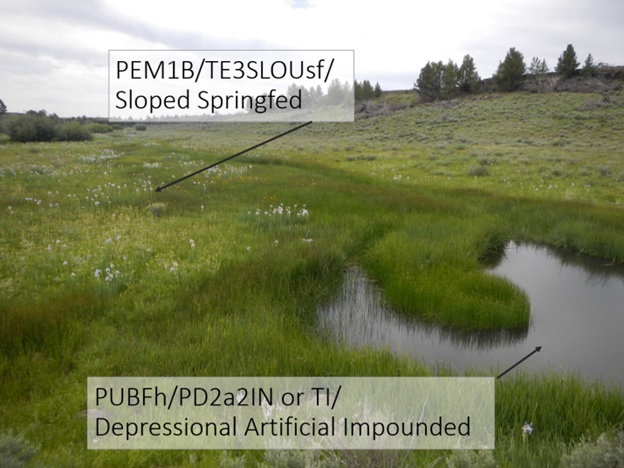
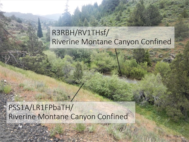
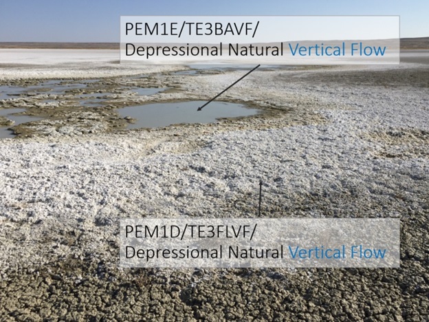
Example Photos
The following photos show example wetlands with their LLWW descriptors.